


Riikonkoski 3D Magnetic Inversion
Riikonkoski is a sizeable copper-gold deposit that has seen little work in the past 50 years. Taranis is in process of evaluating the pre-existing data on the property, that includes diamond drilling, ground magnetic surveys, HLEM surveys, and finally a reconnaissance SkyTEM survey completed in 2011. Geophysical inversions are a complicated process that takes data collected in geophysical surveys, and enables the geophysicist and geologist to create three dimensional models of the subsurface using magnetics, electromagnetics and other geophysical methods. This data can then be correlated with the geology and mineralization found in drill holes to increase knowledge of the subsurface.
Geophysical Inversions of the ground magnetic data are useful for mapping rock formations in the subsurface. They tell the geologists where a deposit might be located, and it also enables a greater understanding of the geology, stratigraphy and structure of the rocks that host the gold deposits. The modeling may even reveal the location of a target, and some indication of the depth of burial and the lateral extent.
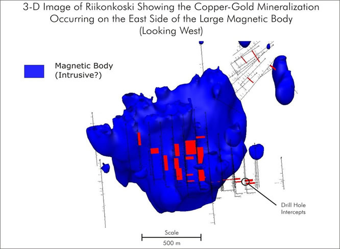
The Spatial Configuration of Riikonkoski Copper-Gold Mineralization:
The drilling completed to data has outlined a mid-size copper deposit that is open in several directions and occurs along the west side of a large magnetic body that measures over 1km in length. Despite the large number of drill holes completed at Riikonkoski, there is not a single drill hole that offers an explanation of what the source of this large magnetic anomaly is. The simplest explanation is that it is an intrusive body - possibly related to mineralization, but it could also pre-date or post the copper gold mineralization found at Riikonkoski. The occurrence of this body adjacent to the copper-gold mineralization is highly suspicious, and needs to be investigated further.